The history of Bac Giang is closely related to the Hung Kings who formed the Van Lang Nation, then followed by the thrones of the Le Dynasty and the Nguyen Dynasty. It was the territory of Da Phuc in the period of King Tu Duc, Vietnam’s last independent monarch. However, the modern province of Bắc Giang was founded in 1895.
The province lies in the Red River Delta and borders Quảng Ninh to the east, Lạng Sơn to the north, Thái Nguyên and the urban district of Sóc Sơn in the capital Hanoi to the west, and Bắc Ninh and Hải Dương to the south
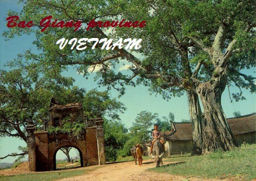
The province has many places of interest to visit such as the Xuong Giang Ancient Citadel, Cam Son Lake, Duc La Pagoda, Tho Ha Communal House and so forth.
Administration in Bac Giang province
Administrative units comprise one city municipality, nine rural districts, seven precincts, 16 town districts and 207 communes. The provincial districts and towns in the province are Son Dong, Luc Ngan, Luc Nam, Yen The, Lang Giang, Yen Dung, Viet Yen, Tan Yen and Hiep Hoa. "Bac Giang Introduction".
History of Bac Giang province
During the time of the Hung Kings, who started the nation of Văn Lang, Bắc Giang was in the division of Võ Ninh.
During the Lê Dynasty, the province was the territory of Bắc Hà. Then it became the region of Thiên Phúc in 1822 in the Nguyen Dynasty. The province later became the prefecture of Đa Phúc during the time of King Tu Duc, Vietnam’s last independent monarch. From November 5, 1889 to September 9, 1891 there existed the province of Lục Nam. It included the districts of Bảo Lộc, Phượng Nhỡn, Lục Nam, Hữu Lũng (split from Lạng Giang and Bắc Ninh Province) and the district of Yên Bái (split from Lạng Sơn Province). In 1891 after the return of the districts of Bảo Lộc and Phượng Nhỡn back to Bắc Ninh Province, Lục Nam was abolished and integrated into Đạo Quan binh I.
Established on October 10, 1895, the current province was originally separated from Bac Ninh Province. It primarily encompassed the prefectures of Lạng Giang and Đa Phúc and the districts of Kim Anh, Yên Dũng, Phượng Nhỡn, Việt Yên, Hiệp Hòa, Yên Thế and some small territories south of the Lục Nam River. The province capital was Phủ Lạng Thương, which is now the city of Bắc Giang. In 1896, the prefecture of Đa Phúc and the district of Kim Anh was returned to Bắc Ninh Province.
In 1950, Bắc Giang was put into the Confederation of Northern Vietnam (Liên khu Việt Bắc) by the communist Vietminh and comprised seven districts: Hiệp Hoà, Lục Ngạn, Yên Thế, Lạng Giang, Việt Yên, Yên Dũng, Hữu Lũng
On February 22, 1955, the district of Sơn Động of Quảng Yên Province was incorporated into Bắc Giang Province. On July 1, 1956, upon the formation of the Autonomous Region of Northern Vietnam (Khu tự trị Việt Bắc), the district of Hữu Lũng was transferred to Lạng Sơn Province. On January 21, 1957, the districts of Sơn Động and Lục Ngạn were divided into the three districts of Sơn Động, Lục Ngạn and Lục Nam. On October 27, 1962, Bắc Giang merged with Bắc Ninh into the new province of Hà Bắc, until it was re-partitioned on January 1, 1997 into its previous components.
Geography of Bac Giang province
Located along the Red River Delta, Bac Giang borders Quảng Ninh to the east, Lạng Sơn to the north, Thái Nguyên and the urban district of Sóc Sơn in the capital Hanoi to the west, and Bắc Ninh and Hải Dương to the south. It includes three land forms namely, the lowland or the delta land, the midland and the mountainous region. While the midland areas are in the districts of Hiep Hoa and Viet Yen and the Bac Giang city, the mountainous districts are the Son Dong, Luc Ngan, Yen The, Tan Yen, Yen Dung, Lang Giang; the seven mountainous districts account for 72% of area of the Bac Giang province.
Of the total land area of the province, 123,000 hectares (300,000 acres) is agricultural land,110,000 hectares (270,000 acres) is forest land, 66,500 hectares (164,000 acres) is residential and urban land and for other uses. The farmland in the province is good intensive farming of rice crops vegetable, fruit and bulb trees. There is scope for expanding land under forests. The produce from the forests has been estimated as 3,5 million m3 of wood and 500 million trees of bamboo and neohouzeaua.
Bắc Giang occupies an area of 3,827.45 square kilometres (1,477.79 sq mi), which is 1.2% of the area of the whole country. According to statistics from 2000, 32.4% of the land is used for agriculture, while 28.9% is used for forestry, industry or is otherwise uncleared. The remainder comprises mountains, unexploited waterways and land used for miscellaneous purposes.
The province is 50 kilometres (31 mi) from Hanoi and has a good network of roads such as the National Highways No. 1A, 31 and 279. It has railway lines from Bac Giang to Hanoi, Lang Son, Thai Nguyen and mineral areas in Quang Ninh by train.
The terrain is moderately mountainous, lying between the high mountains to the north and the Red River Delta to the south. Although a large part of the terrain is mountainous most of it is not isolated. The region to the northern end of the province is mountainous uncleared forest. To the east and southeast of the province is Đông Triều and the Mount Yên Tử, located with the Yên Tử Nature Reserve. The elevation of the province is mostly in the 300–900 metres (980–3,000 ft) range, with a maximum of 1,068 metres (3,504 ft) (Mount Yên Tử). To the northeastern end of the province, along the border with Quảng Ninh there is the Khe Rỗ forest, spanning 71.53 km2, with a rich biodiversity.
Cau River in Viet Yen district, Bac Giang province
Bắc Giang has a total of 347 km of rivers and springs, the three most prominent being Lục Nam River, Thương River and the Cầu River. Apart from waterways, Bắc Giang has many lakes, including Cấm Sơn Lake and Khuôn Thần Lake; the area covered by ponds, lakes and lagoons is 16,300 hectares (40,000 acres). Cấm Sơn Lake lies in Luc Ngan district of the province in the area bordering the province of Lạng Sơn. It is30 kilometres (19 mi) long and has a width varying from 200 metres (660 ft) up to7 kilometres (4.3 mi). It has an area of 26 square kilometres (10 sq mi), but this can increase to 30 kilometres (19 mi) during monsoonal flooding. Khuôn Thần Lake has an area of 2.4 square kilometres (0.93 sq mi) and the centre of the lake has five small hilly islands surrounded by 20-year-old pine forests. Pedalboating and motorboating are permitted on the lake. Ethnic minority hamlets are located on the shores of the lake. Apprroach route to the lake is from Bac Ninh - 31 kilometres (19 mi)), then to Bac Giang - 51 kilometres (32 mi)), further to the Hoa River-98 kilometres (61 mi) and finally arrive at the Cam Son Lake. The highest flow in the Thuong River is reported to be 64.4 m3/s and lowest flow is 12.9 m3/s.
Surrounded by a whole area of 347km of rivers and springs, Bac Giang owns three biggest rivers including Luc Nam River, Thuong River and Cau River. In addition to the river system, the province also has many lakes such as Cam Son Lake and Khuon Than Lake. The area covered by ponds, lakes and lagoons is 16,300 hectares (40,000 acres). ). Cấm Sơn Lake lies in Luc Ngan district of the province in the area bordering the province of Lạng Sơn. It is30 kilometres (19 mi) long and has a width varying from 200 metres (660 ft) up to7 kilometres (4.3 mi). It has an area of 26 square kilometres (10 sq mi), but this can increase to 30 kilometres (19 mi) during monsoonal flooding. Khuôn Thần Lake has an area of 2.4 square kilometres (0.93 sq mi) and the centre of the lake has five small hilly islands surrounded by 20-year-old pine forests. Pedalboating and motorboating are permitted on the lake. Ethnic minority hamlets are located on the shores of the lake. Apprroach route to the lake is from Bac Ninh - 31 kilometres (19 mi)), then to Bac Giang - 51 kilometres (32 mi)), further to the Hoa River-98 kilometres (61 mi) and finally arrive at the Cam Son Lake. The highest flow in the Thuong River is reported to be 64.4 m3/s and lowest flow is 12.9 m3/s.
Climate in Bac Giang province
The province has the typical features of the tropical and temperate climate zone of the Northern Plain. The temperature, humidity and rainfall indexes clearly vary over months and seasons. The climate in the province has been discerned in two distinct seasons - the hot, rainy season from May to September and the cold, dry season from November to March. The average temperature varies between 22–23 °C (72–73 °F); the Maximum Temperatures recorded was 41 °C (106 °F) while the lowest temperature was 13 °C (55 °F). Humidity values are in the range of 73% to 87%. The average rainfall is reported to be 1,953 millimetres (76.9 in). The annual Sun shine hours of 1,500 to 1,700 hours is good to grow tropical and subtropical trees. The average wind velocity is 2.1 metres (6.9 ft)/s and average atmosphere pressure 757.71 mmHg. Since the province is located away from the South China Sea (East Sea), the incidence of hurricanes and storms is rare though Whirlwind and hail storm are a localised phenomenon in a few mountainous districts
Minerals in Bac Giang province
Bac Giang had 63 registered mines in 2005 involved in mining 15 types of minerals such as coal, metal, industrial minerals, building materials. Important mines are the coal mines in Yen The, Luc Ngan and Son Dong districts, which have coal reserves of about 114 million tonnes (including anthracite, lean-coal, peat-coal); Dong Ri mine has 107.3 million tones that has potential for a large scale industrial development. Iron ore reserves (0,5 million tones) have been found in the Yen The district. Bronze ore reserves (100,000 tonnes) has been found in Luc Ngan and Son Dong districts. 3 million tons of Kaolin reserves estimated at 3 million tones has been located in Yen Dung. Large reserves of clay (360 million m3) is concentrated in Viet Yen, Lang Giang, Luc Nam, Yen The and Hiep Hoa districts, about 100 m3 are used to make fire-bricks. Gravel and conglomerates are in Hiep Hoa and Luc Nam districts.
Avifauna in Bac Giang province
A joint survey of the multi-taxa inventory conducted in the Back Giang Province by the Centre for Biodiversity and Conservation at the American Museum of Natural History, New York (CBC-AMNH) and the Institute for Ecology and Biological Resources, Hanoi (IEBR) has recorded 146 species of birds, including 61 species from Khau Ria and Mt Pu Tha Ca and 105 species from Mt Tay Con Linh. New species recorded were “the Beautiful Nuthatch Sitta formosa (Vulnerable), Short-tailed Scimitar Babbler Jabouillea danjoui (Near Threatened), the first record for Vietnam of Yellow-vented Warbler Phylloscopus cantator, and 16 additional species previously unrecorded in East Tonkin. The results indicate that the montane regions of northern Vietnam east of the Red River remain under-surveyed.”
Demographics in Bac Giang province
According to the General Statistics Office of the Government of Vietnam, the population of Bắc Giang province as on 2008 was 1,628,400 with a density of 425 persons per km2 over a total land area of 3,827.45 square kilometres (1,477.79 sq mi) of the province. The male population during this period was 790,300 with females accounting for 838,100. The rural population was 1,473,000 against an urban population of 153,400
According to the census of April 1, 2009, the population was 1,555,720 with a density of 407 people/km², 1.7 times the national average. There are 26 ethnic groups in the province, of these ethnic Vietnamese comprised 88.1%, followed by Nung people with 4.5%, Tay people with 2.6%; San Chay people and San Diu people, both with 1.6%, Hoa people 1.2% and Dao people 0.5%.
Economy of Bac Giang province
Bắc Giang’s land area is primarily dedicated to agriculture. Increasingly, the province is becoming known as a producer of fruit, particularly pineapples and lychees. Around a quarter of Bắc Giang's land area is devoted to forestry. Located 50 km50 kilometres (31 mi) from Hanoi, the province is within economic development zones of the Hanoi - Hai Phong - Quang Ninh Economic Corridor and the Nam Ninh - Lang Son - Hanoi - Hai Phong - Quang Ninh. Before the province was formulated in 1997 and industrial development of the region was initiated, the GDP of the province was only US$ 170 with Agro-Forestry accounting for 55% and Industry hardly contributed. It was a poor economy with 90% of agricultural workers remaining below the poverty line. However, during the period 1997-2008, the province having launched several industrial projects in all its districts, 410 projects were launched with investment of US$ 23.174 billion that included 74 'Foreign Direct Investment' projects worth US$ 432.9 million. As a result, several economic farming models were introduced, which resulted in 'Rural Economic Development', social consumer retail sales, and services got a boost, the poverty rate (2005 level) reduced to 17.78%, and textiles and garment exports accounted to about US$130 million which was 76% of export turnover of the province. Infrastructure facilities such as National Highways and rural roads were substantially expanded, towns were better planned and beautified. Industrial parks, urban Areas-service and high-tech parks are being added. Key Industries like fertilizer, high technology, engineering, building materials, assembling Automobiles, agricultural processing, Forestry products, Textiles and Electric power generation are planned with the objective of achieving a GDP growth rate of 11-12% by 2020. The province has the Bac Giang Department of Industry and Trade established in 2008 by the Bac Giang People’s Committee, which unifies the Department of Industry and the Department of Trade and Tourism; this testifies to the importance given to promote industrial development of the province.
Some of the economic indicators in respect of farming, agriculture and industrial production are the following.
As against the national figure of 7592 of Agriculture, Forestry and Fishery cooperatives there are only agriculture cooperatives in the province. [23] There are 1786 farms as against the national number of 120699. The output value of agriculture produce at constant 1994 prices in the province was 3,491.7 billion đồng against the national figure of 156,681.9 billion đồng. The province produced 569,400 tones of cereals as against the national production of 43.26 million tones The per capita production of cereals in the district was 349.7 kilograms (771 lb) as against the national figure of 501.8 kilograms (1,106 lb) in 2007. In 2007, the industrial output of the province was a meagre 3,868.3 billion đồng of the national output of 1.47 million billion đồng.{itpsharepoint}
